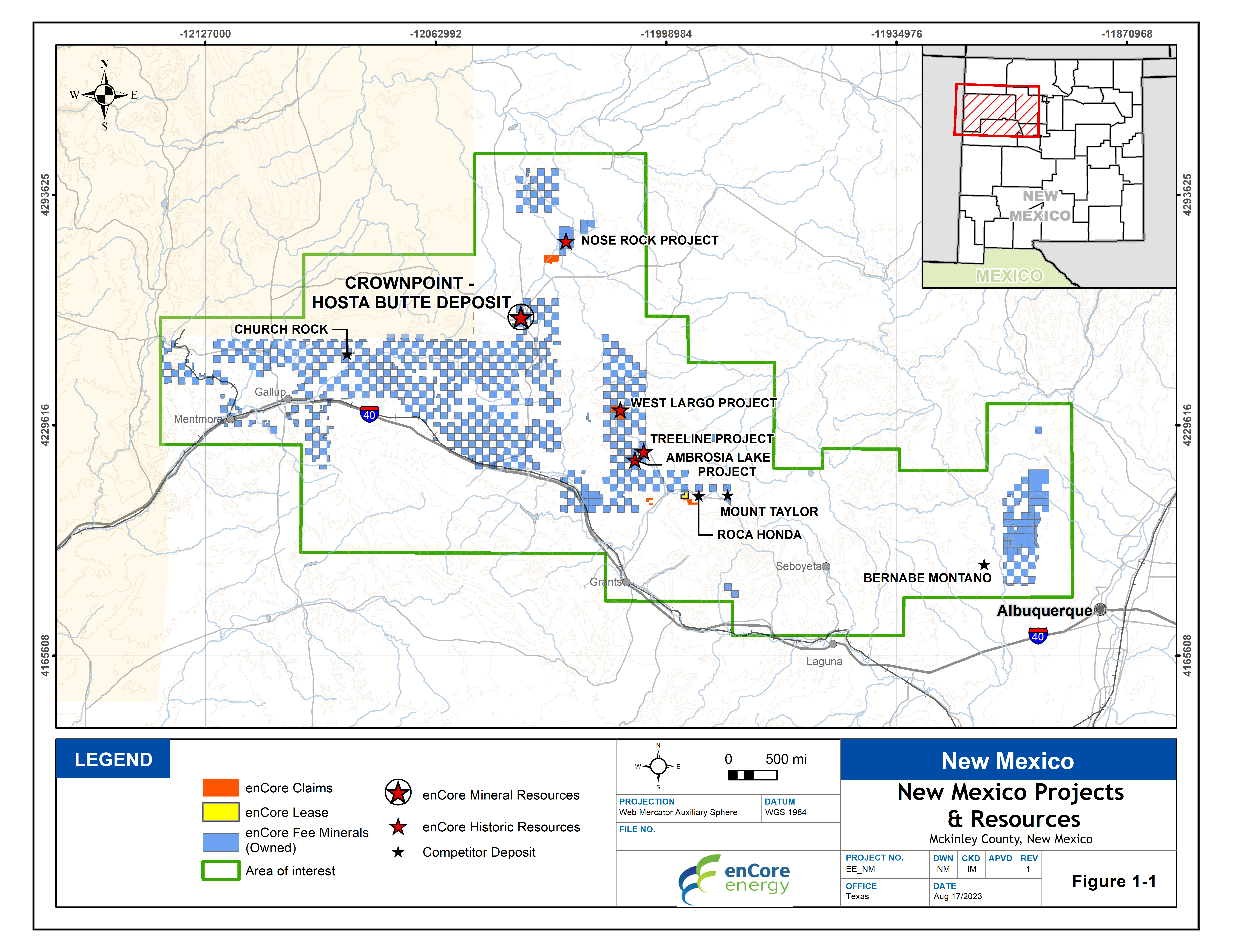
The Crownpoint and Hosta Butte Project is located in the Grants Uranium Region and offers a long-term development opportunity for the Company. The Grants Uranium Region is located in northwestern New Mexico and is part of the Colorado Plateau physiographic province. The Grants Uranium Region has been the most prolific producer of uranium in the United States. With production as early as 1948, over 347 million lbs. of U3O8 have been produced from the region. The majority was produced during the years 1953 through 1990.
Mineral Resources
On February 25, 2022, and revised on March 16, 2022, the Company issued the NI-43-101 Technical Report, Crownpoint and Hosta Bute Uranium Project, McKinley County, New Mexico, USA completed by BRS Inc. and enCore Energy Corp. The report was authored by Douglas L. Beahm, P.E., P.G., Principal, BRS, Inc. and coauthored by Carl Warren, P.E., P.G., Project Engineer, BRS Inc. and W. Paul Goranson, P.E., CEO, enCore Energy Corp. The report provided the following mineral resources.
Total Indicated Mineral Resources |
|||
|
0.02% eU3O8 Grade Cutoff |
Total Indicated Resource |
enCore Controlled |
|
|
Crownpoint |
Pounds eU3O8 |
19,565,000 |
16,223,000 |
|
Tons |
9,027,000 |
7,321,000 |
|
|
Avg. Grade % eU3O8 |
0.108 |
0.111 |
|
|
Hosta Butte
|
Pounds eU3O8 |
9,479,000 |
9,479,000 |
|
Tons |
3,637,000 |
3,637,000 |
|
|
Avg. Grade % eU3O8 |
0.130 |
0.130 |
|
|
Total Indicated |
Pounds eU3O8 |
29,044,000 |
25,702,000 |
|
Tons |
12,664,000 |
10,958,000 |
|
|
Avg. Grade % eU3O8 |
0.115 |
0.117 |
|
Pounds and tons as reported are rounded to the nearest 1,000
*GT cutoff: Minimum Grade (% eU3O8) x Thickness (Feet) for Grade > 0.02 % eU3O8.
Total Inferred Mineral Resources |
|||
|
0.02% eU3O8 Grade Cutoff |
Total Inferred Resource |
enCore Controlled |
|
|
Crownpoint |
Pounds eU3O8 |
1,445,000 |
1,388,000 |
|
Tons |
708,000 |
676,000 |
|
|
Avg. Grade % eU3O8 |
0.102 |
0.103 |
|
|
Hosta Butte
|
Pounds eU3O8 |
4,482,000 |
4,482,000 |
|
Tons |
1,712,000 |
1,712,000 |
|
|
Avg. Grade % eU3O8 |
0.131 |
0.131 |
|
|
Total Inferred |
Pounds eU3O8 |
5,927,000 |
5,870,000 |
|
Tons |
2,420,000 |
2,388,000 |
|
|
Avg. Grade % eU3O8 |
0.122 |
0.121 |
|
Pounds and tons as reported are rounded to the nearest 1,000
*GT cutoff: Minimum Grade (% eU3O8) x Thickness (Feet) for Grade > 0.02 % eU3O8.
View Crownpoint and Hosta Butte Uranium Project Technical Report
Geology and Mineralization
The Project is located in portions of Sections 24, Township 17 North, Range 13 West; Sections 19 and 29, Township 17 North, Range 12 West; and Sections, 3, 9, and 11, Township 16 North, Range 13 West, comprising approximately 3,020 acres mineral estate outright. There are no annual payments, maintenance, or other requirements to be met to maintain the mineral estate subject only to a 3% gross proceeds royalty on uranium mined from the Project. Surface rights are held separately from the mineral rights on the Project. The surface rights have not been removed from development and are not under other restrictions. The property is outside of the Navajo Reservation and is situated on the western edge and to the southwest of the small town of Crownpoint, New Mexico. A portion of the Project is included within the existing NRC source material license area that is held by a subsidiary of Laramide Resources, Ltd.
The Crownpoint area (Sections 24, Township 17 North, Range 13 West; Sections 19 and 29, Township 17 North, Range 12 West) is different than that the of regulatory status of the Hosta Butte property (Sections, 3, 9, and 11, Township 16 North, Range 13 West). The Crownpoint area of the Project is wholly within NuFuels, Inc.’s (a wholly owned subsidiary of Laramide Resources LTD) Source Materials License SUA-1580 for the in-situ recovery (ISR) of uranium which was issued by the US Nuclear Regulatory Commission (NRC) (http://www.nrc.gov/info-finder/materials/uranium). Water rights have been approved by the New Mexico State Engineer for a portion of the Crownpoint area. Other permits will be required to operate the project at the Crownpoint area. There have been no permits or licenses issued for the Hosta Butte property.
Uranium mineralization is typical of sandstone hosted roll-front deposits found within the Western US. The Westwater Canyon member of the Morrison Formation is the principal host of uranium mineralization in the vicinity of the Project and is approximately 360 feet thick. For the purposes of estimating mineral resources, the authors subdivided the Westwater Canyon into four vertically and laterally distinct sand units/zones.
In the Crownpoint area, mineralized thickness ranges from the minimum of 2 feet to over 40 feet. Average thickness of all intercepts was 7.6 feet. Average grade – thickness (GT) of all intercepts was 0.77 ft. Grade varies from the minimum grade cutoff of 0.02 % eU3O8 to a maximum grade by intercept of 0.38 % eU3O8. Individual mineralized trends may persist for several thousand feet with trend width typically in the range from 100 up to 400 feet.
In the Hosta Butte area, mineralized thickness ranges from the minimum of 2 feet to over 33 feet. Average thickness of all intercepts was 7.4 feet. Average GT of all intercepts was 0.83 ft. Grade varies from the minimum grade cutoff of 0.02 % eU3O8 to a maximum grade by intercept of 0.52 % eU3O8. Individual mineralized trends may persist for 2,000 feet or more with trend width typically in the range of 100 to 300 feet.
Previous drilling within the Crownpoint area focused on portions of Sections 19 and 29, T17N, R12W and Section 24 T17N, R13W. Within the Crownpoint area, 482 rotary drill holes and 37 core holes were completed. Previous drilling within the Hosta Butte area was conducted with sections, 3, 9, and 11, T16N, R13W. Previous drilling at Hosta Butte focused primarily on Section 3 with 133 rotary holes and 2 cores holes completed. In Sections 9 and 11, T16N, R13W, 14 rotary drill holes and 32 rotary drill holes were completed, respectively.
Community Engagement
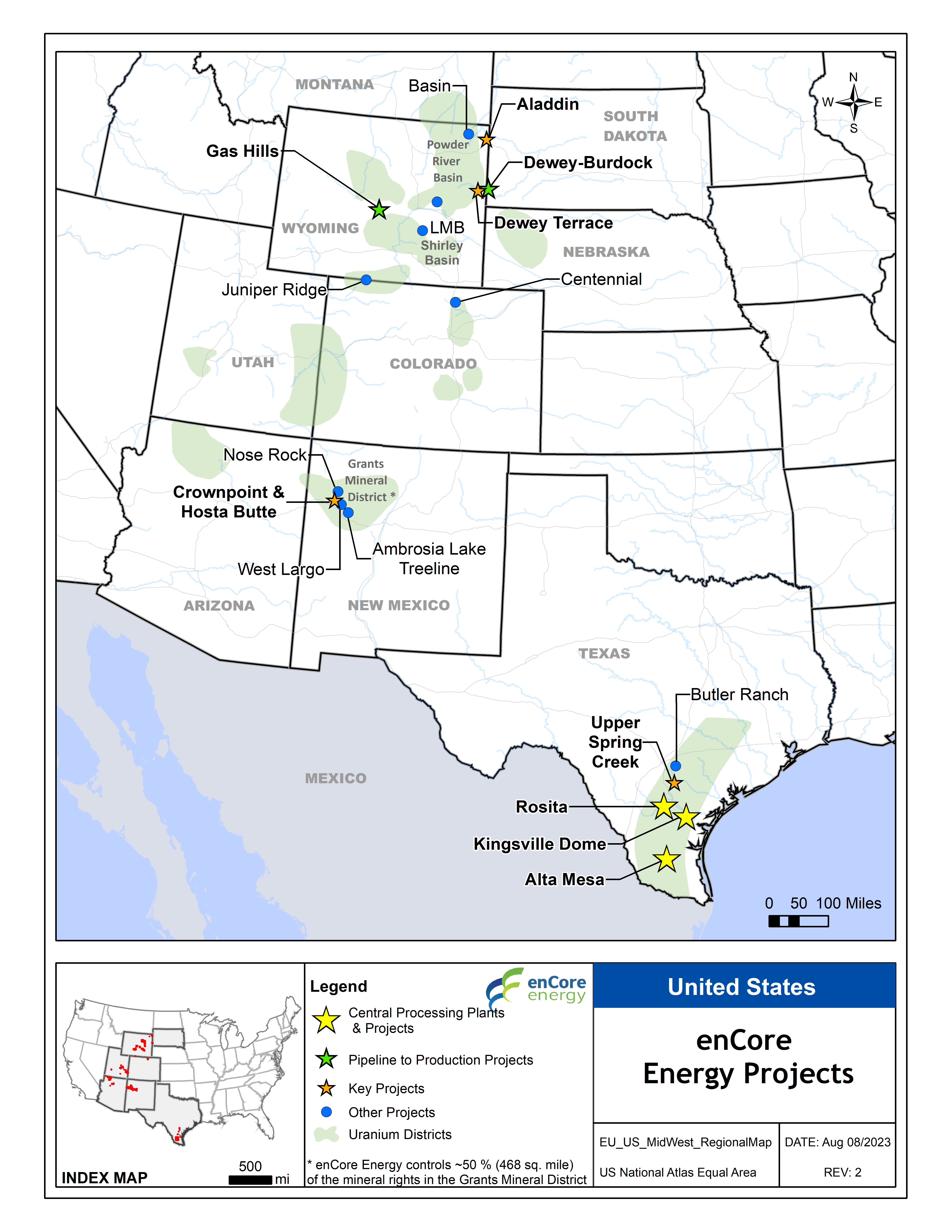
enCore’s assets in New Mexico represent a major long-term asset in our planned production pipeline. enCore has successfully acquired a dominant position in the historic Grants Uranium District in New Mexico. We control mineral rights over approximately 500 square miles containing significant uranium resources located in several different deposits. We are committed to the significant work necessary to overcome legacy issues related to historic uranium mining and milling in New Mexico and its effect on indigenous and local communities. We are executing an engagement strategy with local communities to educate one another and work together to realize economic and social benefits of collectively exploiting these significant resources in an environmentally superior way, unlocking the value of the assets to all parties’ benefit.
Historical Exploration
Uranium was first discovered on the grant lands in New Mexico in 1968 and the project area was extensively explored in the 1970s by Conoco and Westinghouse. Three shafts were sunk into the Section 24 location but with declining uranium prices in the early 1980s, Conoco elected to shut down operations and cap the shafts. Mobil Oil Company also conducted extensive ISR pilot testing in an area 4 miles northwest of the enCore Energy property which successfully confirmed the potential for ISR uranium extraction from the Westwater Canyon Formation.
Frequently Asked Questions
Uranium is already in the underground aquifer, which is why the Environmental Protection Agency has deemed it contaminated and not suitable for drinking water for humans or animals. This groundwater flows through sediments mineralized with uranium. enCore will be removing much of this contaminate. Commercial scale In-Situ Recovery (ISR) uranium extraction has operated in the US for almost 50 years, replacing conventional mining when conditions are appropriate. In these 50 years, no groundwater that has been designated as drinking water quality has been left in a contaminated state after final closure of the uranium extraction operations. Historically, following completion of uranium recovery, these operations have restored the underground aquifer to the same Federal use category it had before extraction began.
The United States Environmental Protection Agency (EPA) reviews every new ISR operation and only authorizes ISR operations in a very specific portion of underground aquifers, which the EPA classifies as contaminated for drinking purposes. Absolutely no activities are allowed outside of this small, designated area. United States Nuclear Regulation Committee (NRC) and State regulations require the company to return the water quality within this area to the same water quality use standards for which it was previously designated. Unlike most water wells, ISR operation wells are cased in heavy duty PVC piping, and once mining operations are complete, are filled with cement, to prevent fluid from entering any other water source or ground interval. During mining operations, groundwater is monitored with electronic and staffed controls as required by regulatory agencies which review the data monthly or quarterly. Any exception must be reported by the operator to these agencies immediately and corrective action immediately implemented.
This is not the cold war era of the 1950s and 1960s when environmental cleanup and employee safety at conventional uranium mines were afterthoughts. Licensing of Crownpoint & Hosta Butte ISR projects requires firm plans for not only development and operations, but also for total reclamation and restoration of both the site and the affected groundwater. enCore will be required to secure and post a total of approximately $15 million in bonds with the Environmental Protection Agency and Nuclear Regulatory Commission (NRC) to ensure sound reclamation. Only when the cleanup is approved, by both the State of South Dakota and the NRC, will the bonds be returned to enCore.
The Nuclear energy industry is the singularly most highly regulated industry in the United States which includes everything from uranium mining to the x-ray in the local hospital. There are no exceptions.
No, enCore does not use harsh chemicals in the uranium extraction process and we only extract uranium from the part of the aquifer designated by the Environmental Protection Agency as contaminated and that cannot be used for drinking water by humans or animals. We will use only gaseous oxygen and a bicarbonate. This is the equivalent of adding oxygen and baking soda to the contaminated underground aquifer, never touching drinking water. In the contaminated aquifer, the gaseous oxygen and bicarbonate within with water dissolves the uranium minerals which exist as coatings on sand grains. We recover this groundwater, along with the dissolved uranium minerals, to our water treatment plant (similar to a home water softener only much larger) where the uranium is removed. Once the uranium is removed, the remaining water is then recycled and returned to the aquifer. Unlike conventional uranium mills, we do not use any acid to dissolve the uranium as they do in foreign countries. The United States has very high environmental standards.
There are 24 reclaimed uranium ISR projects in the United States, with enCore Directors having worked on 10 of these projects. enCore leadership co-invented ISR and has worked in the field for over 40 years building, operating and reclaiming in-situ recovery uranium projects in both Texas and Wyoming.
It is also important to understand that, typically, the reclamation of ISR projects is a continual yet finite process. As enCore works to extract uranium, it builds wellfields in specific patterns and then moves along the uranium resources over time as extraction proceeds. The Company then removes (from production) and reclaims exhausted wellfields as it completes the ongoing extraction process, thereby moving from one area to the next.
The nuclear energy industry is extremely regulated with safety and health regulations in place (including worker safety, air quality, radiation, water quality, spill management and more) that apply not only to on-site facilities but also extend to the transportation of the natural uranium product (yellowcake). Yellowcake is a dry powder. It is sealed in steel containers for transport to a conversion facility where it is transformed into an energy source for domestic and commercial use in the electric grid. It is shipped by tractor-trailer and regulated by the US Department of Transportation with extremely stringent requirements. Yellowcake shipments require advance written notification to the Nuclear Regulatory Commission (NRC) of the planned shipment including the content, quantity, and route to be followed. In addition, only a small number of trucking companies are certified to handle and transport yellowcake.
enCore is a North American company and all benefits stay within the United States. All uranium produced in Crownpoint & Hosta Butte will be sold only to domestic US power companies who use uranium to generate electricity which powers your home and business.
It is expected that activity from development, operations and reclamation will last approximately 20 years and will fuel our economy while creating jobs and strengthen local businesses. It is important to enCore that we provide opportunities for our youth to benefit from the extraction activities through jobs, education and training, thereby allowing our communities and families to grow and prosper.
During uranium extraction operations, large quantities of water from the contaminated underground aquifer circulate through the aquifer to dissolve uranium in the water. The uranium is then recovered in a water treatment plant and the water is reinjected into the ground. Consumptive use of ground water is limited to approximately 1% of the circulated water which typically averages between 50 to 100 gallons per minute. Once extraction is complete, the recirculated water is cleaned, 99% returned to the aquifer and again suitable for the same use that it was prior to enCore’s involvement. It is important that enCore conserve and recycle water, and it is vital to the operations to maintain constant water levels for successful extraction of the uranium. It is imperative that we conduct ourselves as good corporate citizens and contribute in a positive way to the communities in which we work. We must leave a positive legacy which includes valuable infrastructure, water wells, power lines, clean drinking water and vibrant communities with high paying jobs and transferable skills for our youth.
In-situ recovery is not fracking. Fracking utilizes a totally different process than ISR. Fracking opens up preferential “fractures” in the subsurface using extreme pressure in order to provide conduits to extract hydrocarbons. Fracking is not a viable practice for ISR. ISR is designed specifically to avoid opening “cracks” and works by flowing water through existing sediments within an aquifer. Uranium minerals suitable for ISR extraction are deposited as coatings on sand grains and spread across both vertical and horizontal areas of the contaminated underground aquifer. ISR wells are designed to ensure that the water used in injection and extraction flows slowly and consistently through the aquifer in order to contact and dissolve the uranium minerals.
Prior to any extraction activity, enCore is required by law to install a series of water wells within the proposed extraction area – in the contaminated aquifer and within any adjacent aquifers. The water quality in each of these wells is tested by an independent 3rd party (a licensed laboratory) which establishes the baseline water quality and use category of these groundwaters prior to extraction. This establishes the use category enCore will be required meet in reclamation. Pre-extraction levels are established by independent experts, and in reclamation, these independent experts will also verify that pre-extraction level are returned to the aquifer.